What is palaeogeography?
Palaeogeography is the representation of the Earth's past surface. It provides the context within which to understand surface processes, the distribution and history of life and as a critical boundary condition for climate and ocean modelling. But, the link between the geological record revealed at outcrop or in the subsurface, and the contemporary geography is complex, and requires large datasets of geological information and a global perspective. As such it provides the context within which the past history of the Earth is set.
Reconstructing Landscapes
Topography has long been recognized as having a major influence on climate, whether it be cooling due to elevation and the local lapse rate (change in temperature with altitude: on average about 6.5 deg C / 1000m) or as a barrier to circulation, with concomitant downstream affects. Since the topography of the Earth's surface has changed through time in response to tectonics and erosion, this has, not surprisingly, had a major influence on climate change. It is therefore an important boundary condition for climate models . Topography also directly affects sediment supply, in part through climate, but especially through relief and changing drainage, as has been documented by many authors .
A DEM (Digital Elevation Model) is a gridded representation of the Earth's (or any other planet's) relief. The advantage of representing a surface as a grid is that calculations concerning it can be made more easily. This is important for any investigation of the Earth System, especially the interaction of that surface with it's biota and climate. Because of this my recent research has concentrated on trying to develop palaeo-DEMS that robustly represent not only the relief of past time intervals, but also the contemporary drainage. This was presented at the AGU 2001 Fall Meeting (Markwick, 2001) and published in 2004 in a paper by Paul Valdes and myself (Markwick & Valdes, 2004). These methodologies have formed the basis of palaeogeographic work in the exploration industry over the past 15 years. However, new research, publications and insights are pointing to a different approach and this is the focus of active research.
A DEM (Digital Elevation Model) is a gridded representation of the Earth's (or any other planet's) relief. The advantage of representing a surface as a grid is that calculations concerning it can be made more easily. This is important for any investigation of the Earth System, especially the interaction of that surface with it's biota and climate. Because of this my recent research has concentrated on trying to develop palaeo-DEMS that robustly represent not only the relief of past time intervals, but also the contemporary drainage. This was presented at the AGU 2001 Fall Meeting (Markwick, 2001) and published in 2004 in a paper by Paul Valdes and myself (Markwick & Valdes, 2004). These methodologies have formed the basis of palaeogeographic work in the exploration industry over the past 15 years. However, new research, publications and insights are pointing to a different approach and this is the focus of active research.
|
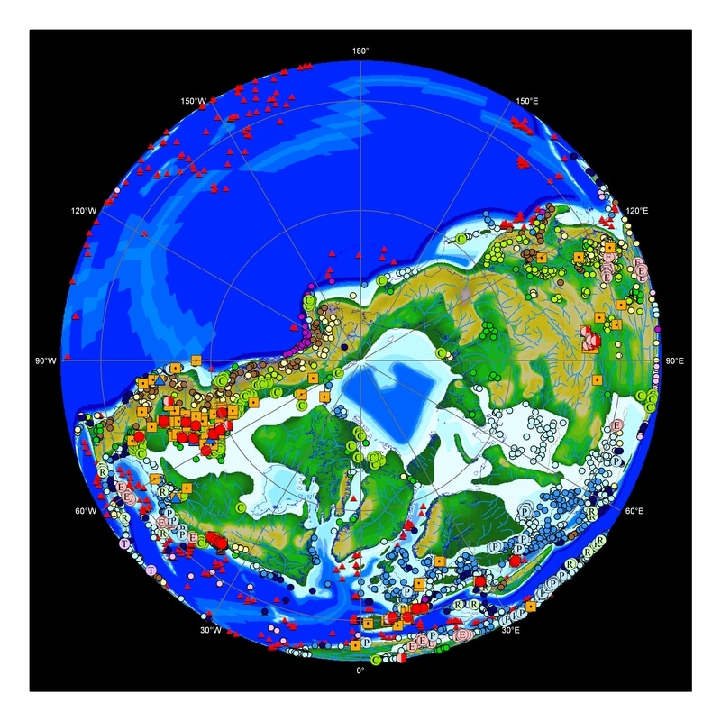
LEFT: DEM for the Maastrichtian land surface; north polar view. The data points include climate proxies (Markwick, 1998, 1997), ODP and DSDP sites and lithological data (PGAP Database). See Markwick & Valdes, 2004 for further information.
|
Plate reconstructions
Plate reconstructions form the basis for all palaeogeography. If the positions of the Earth's tectonic plates is incorrect then this can have major reprecussions on climate modelling work done with the consequent geographies. For the first set of palaeogeographies I have used unpublished reconstructions provided by Professor David Rowley (University of Chicago). As the study has progressed modifications to these reconstructions have shown themselves, which would not have been apparent without this first generation of maps. Changes to the plate model will be included in the next generation of maps.
Generation 1 Palaeogeographies (1997)
The published versions of my 1997 maps are available as images (below). If you need access to the underlying shapefiles for research purposes please contact me directly.
Palaeogeographic maps for the Present Day (and sea-level experiments), Pleistocene (LGM), Pliocene, Miocene, Oligocene, Eocene and Paleocene
|
Palaeogeographic maps for the Cretaceous
|
Frequently asked questions (FAQ) about palaeogeography, the basis of these maps and other useful bits of information
|